
Steve Albers
These pictures and stories are credited to Steve Albers
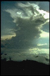
Thunderstorm with anvil as seen from the Black Hills in July, 1979. The anvil forms when the buoyant air in a cumulonimbus cloud reaches a stable layer
(warm stratospheric air). This acts like a mechanical lid forcing the cloud material sideways.
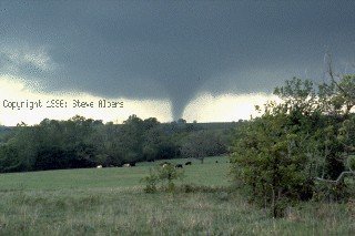
Tornado observed near Sulphur, Oklahoma on May 2, 1984. Location is about 3 miles to our west. This is the first of two tornadoes observed with this
storm, which formed along a dryline. Our position was near the edge of the mesocyclone/wall cloud, thus a large section of the sky appeared to be
spinning like a merry-go-round. The tornado was barely audible and occasional debris was noted (probably the roof of a farm building)
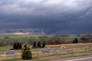
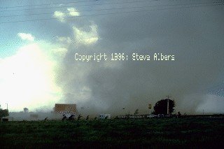
Tornado observed near Custer City, Oklahoma on April 22, 1985. Location is about 5 miles to our NW
 Tornado (actually a landspout) of F2 intensity seen at the KOA campground near Erie, Colorado in 1988. Distance was about 500 feet
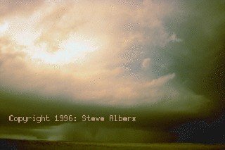 Tornado in Limon Colorado, June 1990, seen from 13 miles SE. The bell shaped cloud base is shown with the tornado dimly visible in the bottom of the
photograph
Tornado in Limon Colorado, June 1990, seen from 13 miles SE. The bell shaped cloud base is shown with the tornado dimly visible in the bottom of the
photograph
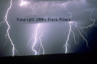
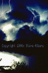 Lightning photo taken from Geronimo, OK on May 1, 1979. The storm was located about 10 miles north in Lawton, producing baseball sized hail and
tornadic "roaring" sounds. The time was approaching midnight. The camera was held steady without a tripod for the time exposure, accounting for the tilt
of the photograph
Lightning photo taken from Geronimo, OK on May 1, 1979. The storm was located about 10 miles north in Lawton, producing baseball sized hail and
tornadic "roaring" sounds. The time was approaching midnight. The camera was held steady without a tripod for the time exposure, accounting for the tilt
of the photograph
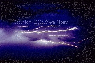
 Lightning photo taken from Geronimo, OK on May 1, 1979. The storm was located about 10 miles north in Lawton, producing baseball sized hail and
tornadic "roaring" sounds. The time was approaching midnight. The camera was held steady without a tripod for the time exposure.
Lightning photo taken from Geronimo, OK on May 1, 1979. The storm was located about 10 miles north in Lawton, producing baseball sized hail and
tornadic "roaring" sounds. The time was approaching midnight. The camera was held steady without a tripod for the time exposure.
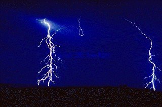
 Lightning photo taken from Parshall North Dakota. The nighttime exposure was about 30sec, but all the lightning in the photo was virtually simultaneous.
This is cloud-to-ground lightning about 5 miles to my east
Lightning photo taken from Parshall North Dakota. The nighttime exposure was about 30sec, but all the lightning in the photo was virtually simultaneous.
This is cloud-to-ground lightning about 5 miles to my east
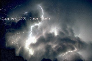
 Lightning photo taken from Parshall North Dakota. This was a high based nocturnal thunderstorm occurring at about 5am CDT. The lightning from this
storm had many short angular branches and traveled a long distance from the high cloud base to ground. The color was an intense white and had
seemingly just one main stroke with no repeat strokes.
Lightning photo taken from Parshall North Dakota. This was a high based nocturnal thunderstorm occurring at about 5am CDT. The lightning from this
storm had many short angular branches and traveled a long distance from the high cloud base to ground. The color was an intense white and had
seemingly just one main stroke with no repeat strokes.
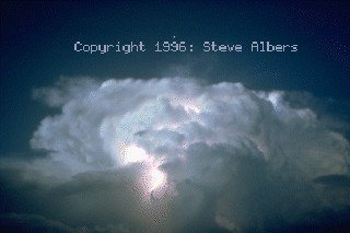
 Lightning photo taken from Parshall North Dakota. This was a high based thunderstorm with intracloud lightning occurring in the vicinity of the cloud base.
With this type of lightning, you could perceive the growth of the channels over several tenths of a second.
Lightning photo taken from Parshall North Dakota. This was a high based thunderstorm with intracloud lightning occurring in the vicinity of the cloud base.
With this type of lightning, you could perceive the growth of the channels over several tenths of a second.
 Lightning photo taken from Parshall North Dakota. Cloud to ground lightning is emanating from the flanking towers of the storm, then travelling perhaps
20000' through clear air down to the ground.
Lightning photo taken from Parshall North Dakota. Cloud to ground lightning is emanating from the flanking towers of the storm, then travelling perhaps
20000' through clear air down to the ground.
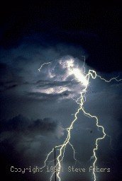
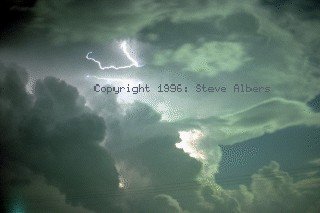 Lightning on the west side of a thunderstorm just E of Colorado Springs. This occurred near midnight with cloud illumination provided by the gibbous
moon located in the southwest. The view is looking SSE. The localized, angular appearance of the channels is characteristic of "high intracloud" lightning
on the underside of anvils of severe storms. Earlier that evening, tornadoes struck near and W of Limon, Colorado
Lightning on the west side of a thunderstorm just E of Colorado Springs. This occurred near midnight with cloud illumination provided by the gibbous
moon located in the southwest. The view is looking SSE. The localized, angular appearance of the channels is characteristic of "high intracloud" lightning
on the underside of anvils of severe storms. Earlier that evening, tornadoes struck near and W of Limon, Colorado
 Thunderstorm moving east from Akron, Colorado in June 1990. The star Vega is visible near the top of the picture. Twilight provides additional
illumination.
Thunderstorm moving east from Akron, Colorado in June 1990. The star Vega is visible near the top of the picture. Twilight provides additional
illumination.